
-
-
A Study on the Skin Friction Characteristics of Barrette Piles at a Construction Site in Singapore
싱가포르 현장 사례를 통한 바레트말뚝의 주면마찰 특성 연구
-
SangIl Kim, Yongkyu Choi
김상일, 최용규
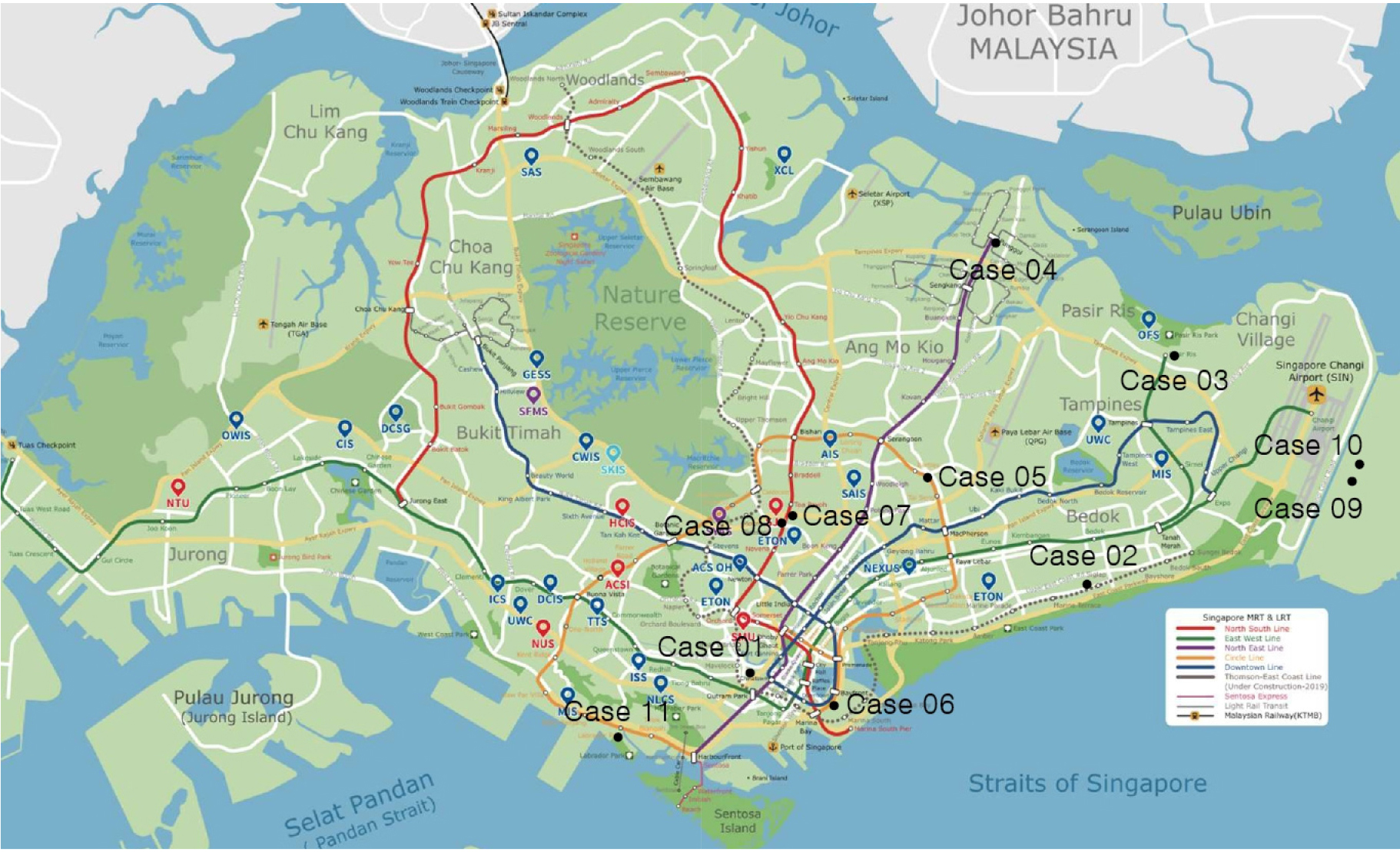
- This study analyzed bidirectional pile load tests and shaft load transfer tests conducted on 11 barrette piles at a construction site in …
본 연구는 싱가포르 현장에서 시공된 바레트 말뚝 11개 사례를 대상으로, 양방향 말뚝재하시험 및 축하중전이시험 결과를 활용하여 수행되었다. 싱가포르 현장의 점토질모래(SC)층 및 풍화암(WR)층을 …
- This study analyzed bidirectional pile load tests and shaft load transfer tests conducted on 11 barrette piles at a construction site in Singapore. Normalized t–z curves were developed by normalizing the unit shaft resistance (f) and displacement (z) with the ultimate unit shaft resistance (fmax) and pile diameter (D), respectively, for clayey sand (SC) and weathered rock layers. The results showed that shaft resistance increased rapidly at small displacements (z/D < approximately 0.05) and gradually approached a plateau, indicating nonlinear mobilization behavior. Because of the variability observed within the same soil layer, upper and lower bound curves were established using an envelope approach in addition to the mean trend. Based on regression analysis of the normalized t–z curves, a logarithmic load transfer function was proposed, showing a strong correlation for the SC layer (N < 100). A quantitative relationship between the SPT N-value and the ultimate unit shaft resistance (fmax) was also established. The proposed functions can be applied in practice by denormalization to estimate the actual shaft resistance and displacement and can be incorporated into load–settlement analyses by applying them to segmented soil layers along the pile depth. This study improves conventional empirical design approaches by providing a measurement-based, practically applicable load transfer model.
- COLLAPSE
본 연구는 싱가포르 현장에서 시공된 바레트 말뚝 11개 사례를 대상으로, 양방향 말뚝재하시험 및 축하중전이시험 결과를 활용하여 수행되었다. 싱가포르 현장의 점토질모래(SC)층 및 풍화암(WR)층을 대상으로 단위주면마찰력(f)과 변위(z)를 각각 극한 단위주면마찰력(fmax) 및 말뚝 직경(D)으로 정규화하여 t–z 곡선을 도출하였으며, 분석 결과 모든 지층에서 z/D < 약 0.05 구간에서 주면마찰력이 급격히 증가한 후 점진적으로 포화되는 비선형 거동이 확인되었다. 또한 동일 지층 내에서도 데이터 분산이 존재함에 따라 평균 거동과 함께 포락선(envelope) 기반의 상·하한 경계 곡선을 제시하였다. 정규화된 t–z 곡선을 기반으로 로그함수 형태의 하중전이 함수를 도출한 결과, SC층(N < 100)에서 높은 상관성이 확인되었으며, N값과 fmax 간의 관계를 통해 지반 강도와 주면마찰력 간의 정량적 상관성을 제시하였다. 제안된 하중전이 함수는 역정규화 과정을 통해 실제 단위주면마찰력 및 변위로 환산이 가능하며, 지층별 분할 적용을 통해 말뚝의 하중–침하 해석에 활용될 수 있다. 본 연구는 계측 기반 데이터를 정규화하고 이를 함수 형태로 일반화함으로써 기존 경험적 설계 방법을 보완할 수 있는 실무 적용 가능한 하중전이 모델을 제시한 데 의의가 있다.
-
A Study on the Skin Friction Characteristics of Barrette Piles at a Construction Site in Singapore
-
-
Characteristic Analysis of Two- and Three-Dimensional Liquefaction Hazard According to Seasonal Groundwater Fluctuations
계절별 지하수위 변동에 따른 2·3차원 액상화 위험도 특성 분석
-
Sunghyuk Park, Teawan Bang, Han-saem Kim, Wanjei Cho
박성혁, 방태완, 김한샘, 조완제
- Liquefaction during earthquakes occurs when soil shear strength is reduced because of an increase in excess pore water pressure, resulting in severe …
지진 시 발생하는 액상화는 과잉간극수압 상승에 따른 유효응력 감소로 지반의 전단강도가 상실되는 현상이며, 이는 상부 구조물의 침하와 지중 시설물의 부상 등 심각한 …
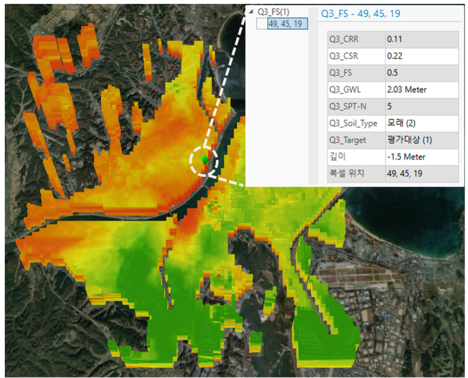
- Liquefaction during earthquakes occurs when soil shear strength is reduced because of an increase in excess pore water pressure, resulting in severe geotechnical hazards such as differential settlement of structures and the uplift of underground facilities. Since the 2017 Pohang earthquake, accurate liquefaction hazard assessment has become increasingly important. However, conventional two-dimensional (2D) assessments often neglect seasonal groundwater fluctuations and cannot adequately characterize the depth-dependent distribution of liquefaction risk. To address these limitations, this study developed 2D liquefaction potential index maps and three-dimensional (3D) factor of safety voxel models by integrating 253 borehole datasets with seasonal groundwater levels for Q1 (dry season) and Q3 (wet season) estimated using Kriging and empirical Bayesian Kriging 3D. The results showed that liquefaction risk consistently increased during the wet season in both models. Notably, the high-risk area identified by the 2D assessment increased by 11.74 percentage points, substantially exceeding the 3.51% increase in high-risk volume observed in the 3D analysis. These findings suggest that 2D assessments may overestimate liquefaction risk because of their simplified weighting scheme. In contrast, the 3D analysis provides a more detailed evaluation of underground infrastructure by identifying depth-specific vulnerabilities. Therefore, integrating both approaches is recommended to improve liquefaction hazard assessment and risk management.
- COLLAPSE
지진 시 발생하는 액상화는 과잉간극수압 상승에 따른 유효응력 감소로 지반의 전단강도가 상실되는 현상이며, 이는 상부 구조물의 침하와 지중 시설물의 부상 등 심각한 도시 재난을 야기한다. 2017년 포항 지진 이후 국내에서도 액상화 위험 예측의 중요성이 증대되고 있다. 하지만 기존 평가는 지하수위의 계절적 변동성을 간과하고 2차원 평면에 국한되어 심도별 위험 분포를 파악하기 어렵다는 한계가 있다. 따라서 실질적인 액상화 위험 관리를 위해서는 지하수위의 시계열적 변동성을 반영함과 동시에, 지하 공간의 위험을 입체적으로 규명할 수 있는 3차원적 평가 체계의 도입이 필수적이다. 이에 본 연구는 Kriging 및 EBK 3D 기법을 통해 도출된 1분기(건기) 및 3분기(우기) 지하수위 분포를 253개 시추공 데이터와 결합하여, 계절적 변동성을 고려한 2차원 액상화 가능성 지수(Liquefaction potential index, LPI) 지도와 3차원 안전율 복셀(Voxel) 모델을 구축하였다. 두 모델을 비교 분석한 결과, 지하수위가 상승하는 우기에 액상화 위험도가 공통적으로 증가하였다. 다만, 고위험군 증가율은 2차원 LPI(11.74%p)가 3차원 복셀 모델(3.51%p)보다 현저히 높았는데, 이는 2차원 모델이 보수적인 위험 지역 선별에는 효과적이나 실제 위험 범위는 과대평가할 수 있음을 시사한다. 결론적으로, 광역적 예비 평가에는 보수적인 2차원 모델이 효율적이나, 지중 구조물의 실질적 안정성을 규명하는 정밀 평가에는 3차원 복셀 모델의 도입이 필수적이다. 따라서 평가의 효율성과 신뢰도를 동시에 확보하기 위해 두 모델을 연계하는 상호 보완적 접근이 요구된다.
-
Characteristic Analysis of Two- and Three-Dimensional Liquefaction Hazard According to Seasonal Groundwater Fluctuations
-
-
Interaction between Shotcrete Leachate and Backfill Material in a Disposal Tunnel
처분터널 내 숏크리트 침출수와 뒤채움재의 상호작용 분석
-
Jeongeum Lee, Seokgu Gang, Jinseop Kim, Yohan Cha, Jongwon Jung
이정음, 강석구, 김진섭, 차요한, 정종원
- High-level radioactive waste repositories must ensure the long-term isolation of radioactive waste from humans and the biosphere. To maintain tunnel stability after …
고준위 방사성 폐기물 처분장은 장기적으로 인간의 생활권 및 생태계로부터 완전한 격리가 요구되어, 이에 따라 처분 시스템의 장기 안정성이 주요 설계 요인으로 고려된다. …
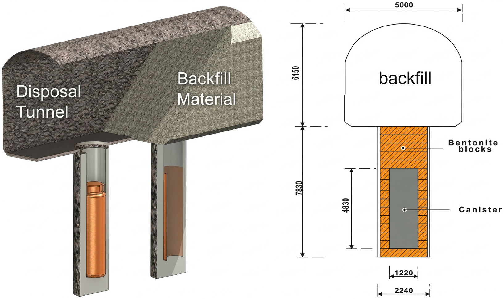
- High-level radioactive waste repositories must ensure the long-term isolation of radioactive waste from humans and the biosphere. To maintain tunnel stability after excavation, shotcrete is installed as a support structure in disposal tunnels, although its application is limited to specific sections. However, the cementitious materials in shotcrete generate highly alkaline leachate, which can degrade the performance of the backfill material. To mitigate this effect, low-pH shotcrete has been developed and adopted in several international repository programs to reduce the alkalinity of cement leachates. Nevertheless, studies on the long-term performance of backfill materials exposed to low-pH shotcrete leachate remain limited in Korea. In this study, low-pH shotcrete was designed and fabricated in accordance with international standards, and its physical and chemical properties were evaluated. In addition, the interactions between low-pH shotcrete leachate and backfill material were quantitatively investigated. The experimental results indicated that the swelling pressure and hydraulic conductivity of the backfill material were primarily governed by dry density and that a dry density of 1.9 g/cm3 satisfied the design requirements. These findings provide essential technical data for the future design of high-level radioactive waste repositories.
- COLLAPSE
고준위 방사성 폐기물 처분장은 장기적으로 인간의 생활권 및 생태계로부터 완전한 격리가 요구되어, 이에 따라 처분 시스템의 장기 안정성이 주요 설계 요인으로 고려된다. 처분장 내 처분터널은 굴착 이후 안정성을 위해 숏크리트와 같은 지보재를 설치하며, 권장되지는 않으나 일부 구간에서 숏크리트가 사용될 수 있다. 권장되지 않는 이유는 숏크리트에 사용되는 시멘트계 재료가 강알칼리성 침출수를 발생시켜 뒤채움재의 성능 저하를 유발하기 때문이다. 이에 따라 해외 선행 연구에서는 침출수의 알칼리성 저감이 가능한 Low-pH 숏크리트가 개발 및 적용되고 있다. 그러나 국내에서는 Low-pH 숏크리트 침출수에 따른 뒤채움재의 성능 변화에 대한 연구가 미비한 실정이다. 따라서, 본 연구에서는 해외 선행 연구 문헌을 바탕으로 Low-pH 숏크리트를 제작하였으며, 물리-화학적 특성을 평가하였다. 또한 Low-pH 숏크리트 침출수를 활용하여 뒤채움재의 상호작용을 평가하였다. 평가 결과, 뒤채움재의 팽윤압 및 수리전도도는 건조밀도에 지배적인 경향을 나타내며, 1.9 g/cm3 건조밀도가 설계기준을 만족하는 것으로 나타났다. 이러한 결과는 향후 고준위 방사성 폐기물 처분장 설계 시 기초 자료로 활용 가능할 것으로 판단된다.
-
Interaction between Shotcrete Leachate and Backfill Material in a Disposal Tunnel
-
-
Identification of Post-Wildfire Landslide High-Risk Zones in Gangneung, South Korea, Using an Integrated Multi-Source Satellite Analysis
다중 위성 자료 통합 분석을 통한 강릉 산불 이후 산사태 고위험지 식별
-
June-Seo Lee, Yeong-Tae Choi, Chan-Young Yune
이준서, 최영태, 윤찬영
- Recent climate change has increased the frequency and intensity of wildfires worldwide, thereby exacerbating post-wildfire slope instability and landslide risk. In this …
기후 변화로 산불의 빈도와 규모가 증가함에 따라, 산불 이후 사면 안정성 저하와 산사태 발생 위험이 중요한 문제로 부각되고 있다. 본 연구는 2023년 …
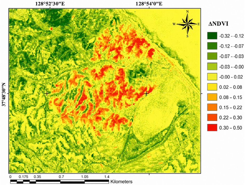
- Recent climate change has increased the frequency and intensity of wildfires worldwide, thereby exacerbating post-wildfire slope instability and landslide risk. In this study, post-wildfire landslide high-risk zones were identified in areas affected by the 2023 Gangneung wildfire through an integrated analysis of multi-source satellite data and Geographic Information System–based spatial overlay. Wildfire-affected areas were delineated using the normalized difference vegetation index (NDVI) derived from Sentinel-2 imagery, while post-fire landslide susceptibility was evaluated using a logistic regression model. Short-term surface deformation was also quantified using differential interferometric synthetic aperture radar (D-InSAR) analysis based on Sentinel-1 data. The integrated results indicated increased landslide susceptibility and surface deformation in the burned areas, demonstrating the applicability of a quantitative multi-source satellite framework for post-wildfire slope hazard assessment.
- COLLAPSE
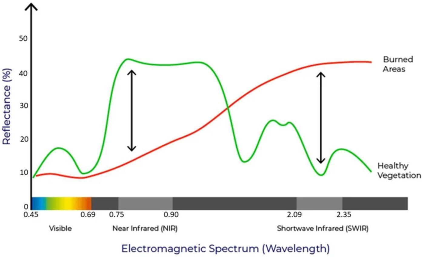
기후 변화로 산불의 빈도와 규모가 증가함에 따라, 산불 이후 사면 안정성 저하와 산사태 발생 위험이 중요한 문제로 부각되고 있다. 본 연구는 2023년 강릉 산불 피해 지역을 대상으로 다중 위성 자료와 GIS 기반 공간 분석을 통해 산불 이후 산사태 고위험지를 도출하였다. Sentinel-2 영상 기반 NDVI 분석을 통해 산불 피해 지역을 식별하고, 로지스틱 회귀모형을 적용하여 산불 이후 산사태 발생 확률을 평가하였다. 또한 산불 피해 지역을 대상으로 Sentinel-1 SAR 기반 D-InSAR 기법을 활용하여 산불 이후 단기 지표 변위를 분석하였다. 분석 결과, 산불 이후 산사태 발생 확률이 증가하였으며, 산불 피해 지역에서 비피해 지역보다 상대적으로 큰 지표 변위가 관측되었다. 최종적으로, 산사태 발생 확률과 지표 변위 정보를 활용한 다중 지표 기반 단계적 선별 체계는 산불 이후 산사태 고위험지를 공간적으로 식별하는 데 활용 가능함을 확인할 수 있었다.
-
Identification of Post-Wildfire Landslide High-Risk Zones in Gangneung, South Korea, Using an Integrated Multi-Source Satellite Analysis
-
-
Evaluation of the Embedment Depth and Pile Spacing of Strand-Connected Back-Supported Piles for Retaining Walls
흙막이벽체와 강연선으로 연결된 배면지지 파일의 근입장 및 간격에 대한 평가
-
Jong-Jin Joo, Jun-Suk Moon, Kang-Il Lee
주종진, 문준석, 이강일
- This study proposes a strand-connected back-supported pile system consisting of double-row H-piles with prestressed steel strands to overcome the structural limitations of …
본 연구는 기존 자립식 흙막이 공법의 구조적 한계를 보완하기 위한 연구로서 H-Pile을 2열로 배치하고 강연선에 프리스트레스를 도입한 것으로 배면지지 파일의 적정 근입장 …
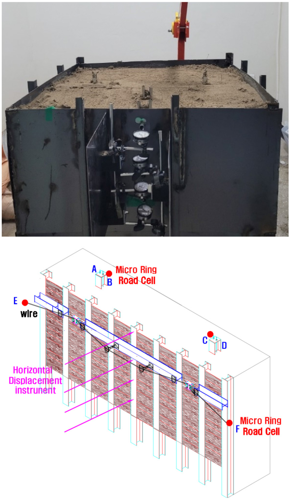
- This study proposes a strand-connected back-supported pile system consisting of double-row H-piles with prestressed steel strands to overcome the structural limitations of conventional self-supported retaining wall systems and to determine the optimal embedment depth and pile spacing. To this end, model tests were conducted by varying the relative density of the sand and the embedment depths of the retaining wall and back-supported piles. In addition, numerical analyses were performed under the same conditions while varying the spacing of the back-supported piles. The results indicated that, to ensure retaining wall stability, the embedment depth of the wall should be at least 3.0m. In particular, under loose sand conditions, the combined embedment depths of the retaining wall and back-supported piles should exceed 9.0m to provide sufficient stability. Furthermore, a pile spacing of 10.8m or less was found to be the most effective for the back-supported piles under all relative density conditions in terms of stability efficiency.
- COLLAPSE
본 연구는 기존 자립식 흙막이 공법의 구조적 한계를 보완하기 위한 연구로서 H-Pile을 2열로 배치하고 강연선에 프리스트레스를 도입한 것으로 배면지지 파일의 적정 근입장 및 수평간격을 산정하는데 목적이 있다. 이를 위해 본 연구에서는 모래의 상대밀도와 흙막이 벽체의 근입장, 배면지지 파일의 근입장을 달리하여 모형시험을 수행하였으며 동일한 조건으로 배면지지 파일의 수평간격을 달리하여 수치해석을 수행하였다. 연구 결과 흙막이 벽체의 안정성을 확보하기 위해서는 흙막이 벽체 근입장을 3.0m 이상 확보가 필요한 것으로 분석되었다. 특히 느슨한 모래지반에서는 흙막이 벽체와 배면지지 파일 근입장의 합을 9.0m 이상 확보하여야 안정성이 확보되는 것으로 분석되었다. 또한 배면지지 파일의 수평간격은 모든 상대밀도 조건에서 10.8m 이하를 적용하는 것이 안정성 측면에서 가장 효과적인 것으로 평가되었다.
-
Evaluation of the Embedment Depth and Pile Spacing of Strand-Connected Back-Supported Piles for Retaining Walls
-
-
Development of a Magnetic Levitation–Friction Hybrid Isolation System and Evaluation of Its Applicability to Pile-Supported Structures
자기부상-마찰식 하이브리드 면진시스템 개발 및 말뚝지지 구조물 적용성 평가
-
Jungwon Yun
윤정원
- This study proposes a magnetic levitation–friction hybrid isolation system that actively controls frictional resistance by distributing vertical loads through magnetic levitation while …
본 연구에서는 마찰형 면진 시스템의 에너지 소산 능력은 유지하면서, 자기부상력을 활용하여 수직하중을 분담함으로써 마찰력을 능동적으로 제어할 수 있는 자기부상-마찰식 하이브리드 면진 시스템을 …
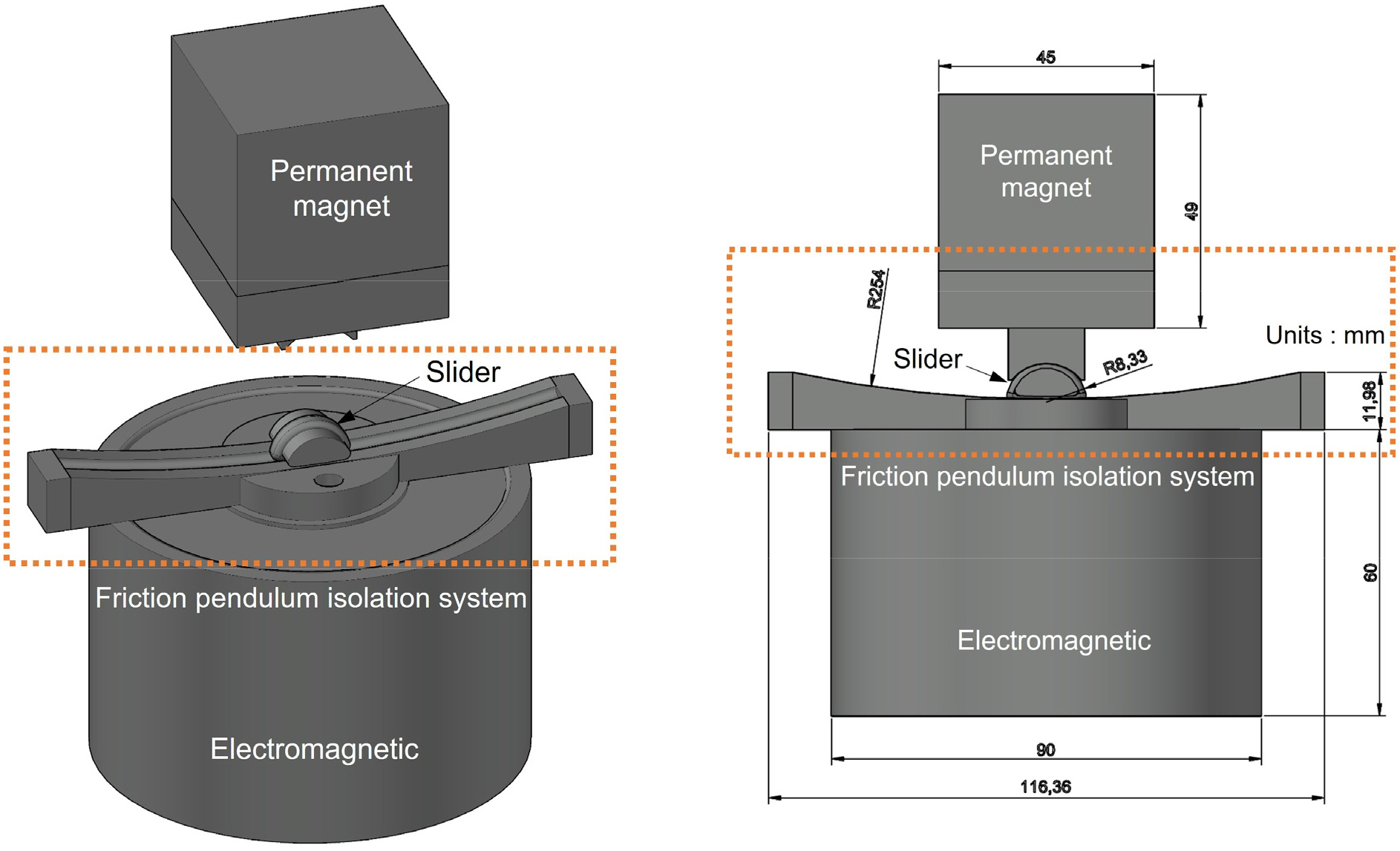
- This study proposes a magnetic levitation–friction hybrid isolation system that actively controls frictional resistance by distributing vertical loads through magnetic levitation while preserving the superior energy dissipation capacity of conventional friction-based isolation systems. To investigate the dynamic response of pile-supported structures incorporating the proposed system under seismic loading, a series of shaking table tests was conducted. First, performance evaluation of the hybrid isolation unit demonstrated that increasing the control voltage enhanced the magnetic levitation force, thereby transferring a portion of the vertical load and reducing the frictional resistance at the contact interface. Consequently, the hysteresis loops exhibited a more pronounced parallelogram shape, indicating significantly improved energy dissipation capacity. Subsequently, shaking table tests on a pile-supported structure confirmed that active control through magnetic levitation achieved an additional reduction in acceleration of up to 17% compared with conventional friction-based isolation systems. These findings demonstrate that the proposed hybrid isolation system can effectively enhance the seismic performance of pile-supported structures, particularly under high-frequency seismic excitations.
- COLLAPSE
본 연구에서는 마찰형 면진 시스템의 에너지 소산 능력은 유지하면서, 자기부상력을 활용하여 수직하중을 분담함으로써 마찰력을 능동적으로 제어할 수 있는 자기부상-마찰식 하이브리드 면진 시스템을 제안하였다. 제안된 시스템을 말뚝 두부에 적용하여 지진 시 말뚝지지 구조물의 동적 응답 특성을 규명하고자 진동대 실험을 수행하였다. 먼저, 하이브리드 면진 시스템의 진동대 실험 결과, 제어 전압이 증가함에 따라 자기부상력이 수직 하중을 효과적으로 분담하여 접촉면의 마찰 저항을 감소시키는 것으로 나타났다. 특히 이력 곡선이 평행사변형 형태로 변화하여 에너지 소산 능력이 유의미하게 향상됨을 확인하였다. 다음으로, 말뚝지지 구조물의 거동을 평가하기 위한 진동대 실험을 수행한 결과, 전압 제어를 통해 자기부상력을 발생시키는 경우 기존 마찰형 면진 시스템 대비 최대 17%의 추가적인 가속도 저감 효과를 확보할 수 있음을 입증하였다. 이는 본 하이브리드 면진 시스템이 고진동수 대역의 지진 하중 하에서 구조물의 안정성을 개선할 수 있음을 시사한다.
-
Development of a Magnetic Levitation–Friction Hybrid Isolation System and Evaluation of Its Applicability to Pile-Supported Structures
-
-
Evaluation of the Elastic Modulus of Micropiles through Field Tension Tests
현장인장시험을 통한 마이크로파일의 탄성계수 평가
-
Kwang-Young Kim, Yeon-Sung Moon, Kang-Il Lee
김광영, 문연성, 이강일
- Micropiles are small-diameter cast-in-place piles composed of a steel bar, grout, and steel casing. Initially developed to support existing structures and control …
마이크로파일은 강봉과 그라우트 및 케이싱으로 구성된 소구경 현장타설말뚝을 말한다. 이 파일은 개발 당시 기존 구조물의 지지력 보강 또는 침하억제를 위한 목적으로 활용되었으나, …
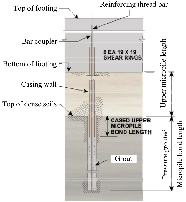
- Micropiles are small-diameter cast-in-place piles composed of a steel bar, grout, and steel casing. Initially developed to support existing structures and control settlement, they are now also widely used to support the foundations of new structures and resist uplift forces. As the use of micropiles has increased, studies have primarily focused on the bearing behavior of micropiles and micropiled rafts. However, investigations into the composite behavior and stiffness of micropiles composed of multiple materials remain limited. Consequently, whether such micropiles exhibit integrated structural behavior in the ground remains controversial. To address this issue, field tension tests were conducted on micropiles installed at nine sites in Korea, and their stiffness was evaluated through a comprehensive analysis of the test results. The results confirmed that the micropiles exhibited integrated behavior and that their stiffness was approximately 1.06–1.69 times greater than the theoretical values calculated by considering the cross-sectional area and elastic modulus of each constituent material independently. Overall, the tensile deformation behavior of composite micropiles demonstrated integrated behavior, and the elastic modulus derived from the field test results was approximately 1.06–1.69 times greater than the theoretical elastic modulus calculated from the cross-sectional area and elastic modulus of the individual constituent materials.
- COLLAPSE
마이크로파일은 강봉과 그라우트 및 케이싱으로 구성된 소구경 현장타설말뚝을 말한다. 이 파일은 개발 당시 기존 구조물의 지지력 보강 또는 침하억제를 위한 목적으로 활용되었으나, 최근에는 신설 구조물기초 하부 지지 또는 상향력에 저항하기 위한 목적으로 활용되고 있다. 마이크로파일의 활용이 증가함에 따라 마이크로파일 또는 마이크로파일-기초에 관한 지지특성에 관한 연구가 주로 수행되었다. 그러나 복합재료로 구성된 마이크로파일의 일체화 거동과 말뚝강성의 평가에 관한 연구는 부족한 실정이다. 본 연구에서는 이와 같은 문제를 해결하기 위해 국내 9 개소 현장에 설치된 마이크로파일을 대상으로 인장시험을 수행하였고, 시험결과를 종합적으로 분석하여 마이크로파일의 강성을 평가하였다. 연구결과, 복합재료로 구성된 마이크로파일의 인장변형 특성은 일체화 거동을 보이며, 현장시험을 고려한 마이크로파일의 탄성계수가 재료별 단면적과 탄성계수를 고려한 마이크로파일의 탄성계수보다 약 1.06~1.69 배 증가됨을 확인하였다.
-
Evaluation of the Elastic Modulus of Micropiles through Field Tension Tests
-
-
Analysis of the Effects of Training Conditions on Deep Learning-Based Prediction of Liquefaction-Induced Damage to Caisson-Type Quay Walls
액상화에 의한 딥러닝 기반 케이슨식 안벽 피해 예측을 위한 학습 조건의 영향 분석
-
Hyeonsu Yun, Seong-Kyu Yun, Jiseong Kim, Gichun Kang
윤현수, 윤성규, 김지성, 강기천
- Recent studies in geotechnical engineering have increasingly focused on deep learning-based approaches for the rapid prediction of structural responses under seismic loading. …
최근 지반공학 분야에서는 지진 시 구조물 응답을 신속하게 예측하기 위한 딥러닝 기반 연구가 활발히 수행되고 있다. 특히 액상화 지반에서의 케이슨식 안벽과 같은 …
- Recent studies in geotechnical engineering have increasingly focused on deep learning-based approaches for the rapid prediction of structural responses under seismic loading. In particular, caisson-type quay walls constructed on liquefiable ground exhibit time-dependent nonlinear behavior, creating a growing demand for data-driven prediction methods that can replace repetitive numerical analyses. However, existing studies have primarily focused on improving the prediction accuracy of deep learning models, whereas systematic investigations of how training conditions affect prediction stability and reliability remain limited. Therefore, this study constructed time-series datasets of settlement and horizontal displacement using FLIP numerical analyses under various ground conditions (SPT N-values) and seismic intensities (0.1–2.0 m/s2). Based on these datasets, the effects of training conditions on the prediction performance and stability of deep learning models were evaluated. The results demonstrated stable prediction performance and reproducibility for batch sizes of 8–32, whereas the batch size of 64 resulted in increased prediction variability.
- COLLAPSE
최근 지반공학 분야에서는 지진 시 구조물 응답을 신속하게 예측하기 위한 딥러닝 기반 연구가 활발히 수행되고 있다. 특히 액상화 지반에서의 케이슨식 안벽과 같은 항만 구조물은 시간 의존적 비선형 거동을 보이기 때문에, 반복적인 수치해석을 대체할 수 있는 데이터 기반 예측 기법의 필요성이 증가하고 있다. 그러나 기존 연구는 주로 딥러닝 모델의 예측 정확도 향상에 초점을 두고 있으며, 학습 조건에 따라 예측 결과의 안정성과 신뢰성이 어떻게 변화하는지에 대한 체계적인 분석은 부족한 실정이다. 이에 본 연구에서는 FLIP 수치해석을 통해 다양한 지반 조건(N치)과 지진동 세기(0.1~2.0 m/s2)에 따른 침하량 및 수평변위의 시계열 데이터를 구축하고, 이를 기반으로 딥러닝 모델의 학습 조건이 예측 성능 및 결과 안정성에 미치는 영향을 분석하였다. 분석결과 batch size 8~32 범위에서는 안정적인 예측 성능과 재현성이 확보된 반면, batch size 64 조건에서는 변동성이 증가하는 경향이 나타났다.
-
Analysis of the Effects of Training Conditions on Deep Learning-Based Prediction of Liquefaction-Induced Damage to Caisson-Type Quay Walls
-
-
Data Augmentation via Gaussian Noise Injection for Simulation Data-Based Prediction of Retaining Wall Behavior under Field Variability
해석 데이터 기반 흙막이 벽체 거동 예측에서의 현장 변동성을 고려한 가우시안 노이즈 주입 데이터 증강 기법
-
Jihoon Kim, Inyoung Huh, Jingi Hong, Heejung Youn
김지훈, 허인영, 홍진기, 윤희정
- This study presents a Gaussian noise–based data augmentation strategy to improve the predictive performance of a multi-resolution ConvLSTM framework for predicting retaining …
본 연구에서는 굴착에 따른 흙막이 벽체의 변형 예측을 위한 다중 해상도 ConvLSTM 프레임워크의 성능 향상을 위해 Gaussian noise 기반 데이터 증강 기법을 …
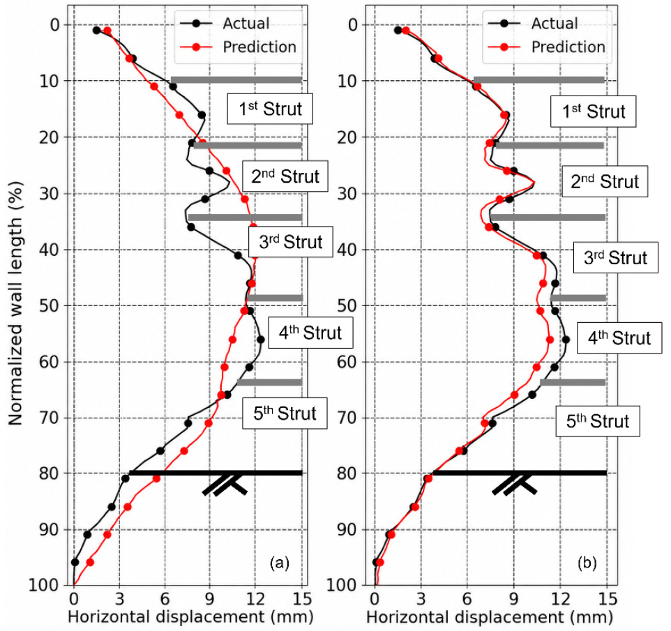
- This study presents a Gaussian noise–based data augmentation strategy to improve the predictive performance of a multi-resolution ConvLSTM framework for predicting retaining wall deformation during excavation. Although an initial training database comprising 4,200 samples was generated using finite element analysis (PLAXIS 2D), the dataset was inherently limited by the idealized, smooth deformation patterns typically produced by numerical simulations. Consequently, it could not adequately represent the localized and irregular deformation characteristics observed under field conditions. To address this limitation, Gaussian noise with varying spatial resolutions and amplitudes was injected into the simulation-based displacement data, expanding the database to 16,800 samples. The trained model was subsequently validated using 34 inclinometer datasets collected from 11 excavation sites in South Korea. The results demonstrated that the proposed data augmentation strategy effectively mitigated overfitting to idealized simulation data, significantly improving the prediction accuracy and reproducibility of diverse, irregular deformation patterns observed in the field while reducing prediction uncertainty.
- COLLAPSE
본 연구에서는 굴착에 따른 흙막이 벽체의 변형 예측을 위한 다중 해상도 ConvLSTM 프레임워크의 성능 향상을 위해 Gaussian noise 기반 데이터 증강 기법을 제안하였다. 기존 유한요소해석(PLAXIS 2D)을 이용하여 4,200개의 학습 데이터베이스를 구축하였으나, 해당 데이터는 수치해석 특성상 정형화되고 평활한(smooth) 변형 형상만을 나타내므로 실제 현장에서 관측되는 국부적이고 불규칙한 변형 특성을 반영하지 못하는 한계가 있었다. 이를 개선하기 위하여 다양한 공간 해상도와 진폭을 갖는 Gaussian noise를 수치해석 기반 변위 데이터에 주입하여 데이터베이스를 16,800개로 확장하였다. 학습된 모델은 국내 11개 굴착 현장에서 수집된 34개의 지중경사계 계측자료를 이용하여 검증하였다. 분석 결과, 제안된 데이터 증강 기법은 이상적인 해석 데이터에 대한 과적합을 방지하여 실제 현장의 다양한 불규칙 변형 형상에 대한 예측 정확도와 재현성을 유의미하게 개선하였으며, 예측 불확실성을 감소시키는 것으로 나타났다.
-
Data Augmentation via Gaussian Noise Injection for Simulation Data-Based Prediction of Retaining Wall Behavior under Field Variability
-
-
Post-Wildfire Debris-Flow Likelihood Assessment for Expressway-Adjacent Watersheds in South Korea Using the USGS M1 Model
USGS M1 모델 기반 산불 이후 고속도로 인접 유역의 토석류 발생가능성 평가
-
Suho Cho, Han-Saem Kim, Bumsik Hwang, Teawan Bang, Wanjei Cho
조수호, 김한샘, 황범식, 방태완, 조완제
- Post-wildfire debris flows can occur rapidly during short-duration rainfall events because wildfires alter vegetative cover, soil properties, and surface runoff processes. However, …
산불 이후 토석류는 식생 소실, 토양 표면 특성 변화, 지표유출 증가로 인해 단시간 강우 조건에서도 급격히 발생할 수 있다. 그러나 국내 고속도로 …
- Post-wildfire debris flows can occur rapidly during short-duration rainfall events because wildfires alter vegetative cover, soil properties, and surface runoff processes. However, conventional debris-flow risk-assessments for Korean expressways have primarily focused on topographic and structural vulnerability factors without explicitly considering wildfire-induced changes in the debris-flow likelihood assessment. Therefore, this study examines the preliminary applicability of the U.S. Geological Survey M1 post-wildfire debris-flow likelihood model to a wildfire-affected watershed adjacent to an expressway in South Korea. The model was implemented using a satellite-derived difference normalized burn ratio, a digital elevation model, rainfall data from a nearby automatic weather station, and information on soil erosion. The calculated likelihood based on the M1 model exceeded 80% for the investigated watershed under the selected post-wildfire rainfall conditions. Additionally, based on the existing expressway debris-flow assessment, the site was classified as grade C. The estimated debris-flow volume was <1,000 m3, which corresponds to a moderate volume class in the USGS framework. These results indicate that the M1 model provides useful supplementary information for screening post-wildfire debris-flow-prone watersheds. However, further validation and regional calibration are required for Korean geomorphological, hydrological, and soil conditions.
- COLLAPSE
산불 이후 토석류는 식생 소실, 토양 표면 특성 변화, 지표유출 증가로 인해 단시간 강우 조건에서도 급격히 발생할 수 있다. 그러나 국내 고속도로 토석류 위험도 평가체계는 주로 지형 조건, 대책시설, 퇴적 및 도로 피해 가능성에 기반하고 있어 산불로 인한 토석류 발생가능성 증가를 명시적으로 반영하는 데 한계가 있다. 본 연구에서는 미국 지질조사국(USGS)의 산불 후 토석류 발생확률 예측모델인 M1 모델을 국내 산불 피해 고속도로 인접 유역에 시범 적용하고, 국내 적용 가능성을 예비적으로 검토하였다. 입력자료로는 위성영상 기반 dNBR, 수치표고모델, 인근 AWS 강우자료, 토양침식인자를 활용하였다. 분석 결과, 대상 유역의 M1 기반 토석류 발생확률은 선정된 산불 후 강우 조건에서 80% 이상으로 산정되었으며, 기존 고속도로 토석류 위험도 평가 결과는 C등급으로 나타났다. 또한 USGS 토석류량 예측모델에 따른 추정 토석류량은 1,000 m3 이하로 산정되어 중간 수준의 규모 등급에 해당하였다. 본 연구 결과는 M1 모델이 산불 이후 토석류 취약 유역의 신속한 선별을 위한 보조 지표로 활용될 수 있음을 시사한다. 다만 국내 지형, 강우, 토양 및 산불 피해 특성을 반영한 추가 검증과 지역화 보정이 필요하다.
-
Post-Wildfire Debris-Flow Likelihood Assessment for Expressway-Adjacent Watersheds in South Korea Using the USGS M1 Model

Journal Informaiton
 Journal of the Korean Geotechnical Society
Journal of the Korean Geotechnical Society


한국지반공학회
The Korean Geotechnical Society, #701, C-dong (H business PARK), 26, Beobwon-ro 9-gil, Songpa-gu, Seoul 05836, South Korea
Tel: +82-2-3474-4428, 3474-7865 / Fax: +82-2-3474-7379 / E-mail: kgssmfe@hanmail.net Copyright© The Korean Geotechnical Society. Powered by APUB
Tel: +82-2-3474-4428, 3474-7865 / Fax: +82-2-3474-7379 / E-mail: kgssmfe@hanmail.net Copyright© The Korean Geotechnical Society. Powered by APUB